2003 07 27 Pyramid Lake, Smoke Creek, Black Rock
2003 07 28 Truckee to Elko NV, Tuscarora
2003 07 29 Elko NV to Mountain Home ID, Bruneau Dunes
2003 07 31 Bruneau Dunes, ID, Sun Valley, ID
2003 08 01 Mountain Home ID to Ely NV
2003 08 04 Ely to Fallon NV, Eberhart, Dixie Valley
2003 07 31 Bruneau Dunes, ID, Sun Valley, ID
Looks like I got the date and day and even the year right this time ..
Another scorching hot day today. I am not sure it hit 105, but it might have hot 104. And it was windy late in the day making it seem even hotter and drier. There is a measure called "evaporation potential" used to measure the aridity of an environment, and I am sure it was off the scale here today. It measures the amount of water (in inches, or mm, or whatever) that will be evaporated in a given unit of time. Death Valley commonly leads the league in this measure, but I think today the Snake River Plain would give DV a run for its money.
Anyway, it was a decent day for photos. I was up well before dawn again and out on the dunes. I am getting to know them better - where to be when and when not to be where and so forth. Basically these dunes have to be photographed at dawn, at least this time of year. The dunes run more or less east-west, with the sun rising a bit south of the east end of the dunes and setting a bit north of the west end. The morning light is also redder and much more pleasing. The sunset light is harsh and flat for whatever reason. Also the side of the dunes that is illuminated in the evening is the mush less interesting side. So between the heat and being tired and finally figuring that out I did not even bother going back for sunset.
The sunrise from the dunes was nice..
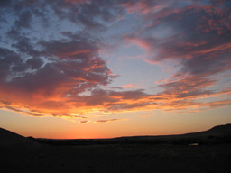 |
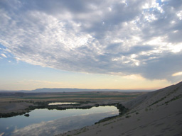
However, a nice sunrise below clouds like this means inevitably that the sun is going to float up right into those same clouds .. meaning no shadows, meaning a lot of sitting around waiting for the clouds to vanish or one's patience to run out. This time the clouds slowly drifted off before I got impatient enough to leave. The sun was high enough though that the light was not the best. But I got a few good ones, sort of like these..
 |
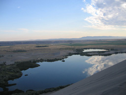 |
Actually not much like those, now that I look at them. Those two show what the light was like before the clouds finally beat it. I did take a lot of the water and various reflections though.
The ridge in the middle distance is the north face of the shallow canyon that the Snake River flows through. The green is all heavily irrigated corn and other stuff I could not identify. More about that later.. If you look very carefully at the above pic you can see the observatory just to the left of the smaller lake.
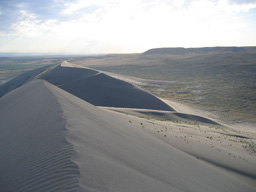
I did make it all the way to the top of the tallest dune this morning. It's much easier from the west than the east..
 |
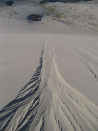 |
The above shows a sand "river" flowing down and away from me as a result of footsteps. It's hard to tell, but this sand river is about 200 or 250 feet long. The horizontal line at the base of the steep part of the dune is a long way down!
After all this I took myself on a fairly long round trip drive to Ketchum Idaho, about 100 miles away. It's a beautiful drive, about 3/4 of which is dead flat driving across the Snake River plain. Some winding up into the mountains, and then you are in the Wood River Valley, which is quite narrow. The Sawtooth Mountains just jump up out of the valley. It literally looks like the earth folds up in a nice crease and makes 45 degree slopes. Very cool. The Sawtooth mountains around this valley are gorgeous and sage covered at lower elevations and pine covered above. They seem to be perfect conical mountains all smashed together. I was so into just looking I forgot to make any snapshots.
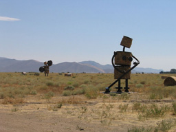
On the way into the valley from the plain you see this:
 |
 |
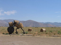 |
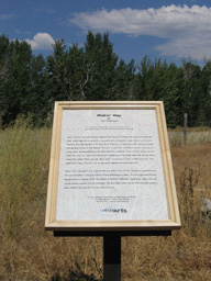
I guess that is semi-legible. It basically says that what you're looking at is art meant to commemorate what the plain is all about.
The Wood River Valley and Ketchum and Sun Valley are not about hay. They are about money and skiing and second homes and spectacular scenery. Ketchum is basically a very small little Palo Alto up in the trees. You have your swell bookstore (which I liked), your swell grocery store where you can choose just the right arugula leaves, the swell wine shop, lots of realtors, a nice art center, many swank shops, many swell restaurants, many swell celebrity second homes, and a lot of swell LA (and other) money. But, I think you also have the worlds toughest zoning laws. In spite of the tremendous piles of money obviously washing around here it is quite nice. And the Sun Valley Ski hill looks pretty swell too, at least from the valley floor. (As an aside I can report that there is a small town near here named "Picabo", so either the skier is named for the town, or the town is named for the skier, or they are both named for something else.) In spite of all you just read I actually liked the place. Really. But if you want to live here in Ketchum bring your entire wallet. You'll need it.
Not wanting to get kicked out by the coolness police for not looking like a local I hid the camera and didn't make any snaps.
Now I wish I had some snaps of the mountains and the town. Oh well. Next time.
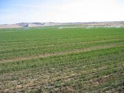
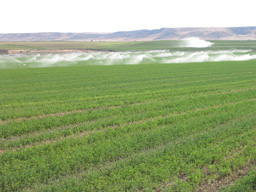
On the way back I did take some photos from a distance of the dunes:
 |
 |
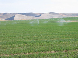 |
Is something wrong with this scene? What does this tell you about the cost of water in the Snake River Plain? You see a lot of corn growing here! (Also hay, alfalfa, sugar beets..) Corn! One of the most water intensive crops there is, and they are growing it in a desert! It was about 105 and windy when I took all these. I don't think much of that water was making it into the plants, as nice as it all looked. And you see irrigation like this all over around here.
I have a feeling our tax dollars are hard at work here. I could rant for a while about farm subsidies but I won't.
Tomorrow I am up and out of here once more for the dunes at dawn, and then will be fleeing to Nevada to get out of this heat. Ely sounds good. It's over 6000 feet..
More tomorrow..